- The Weather Retort
- Posts
- From fire to ice: Jet stream dip sweeps east across Lower 48
From fire to ice: Jet stream dip sweeps east across Lower 48
Historic fires continue in California as responsible entity cranks out new winter storm.
Ian Livingston
January 10, 2025
As a forecaster, journalist and certified weather freak (there's a badge, trust me), a big part of my job is analyzing the playing field of global weather and related climate change stories to decide which ones to spend more time on.
In this every-weekday newsletter, I'm going to bring that directly to you.
Wait a few (and check these stories)
“If you don't like the weather in New England, just wait a few minutes.” -Mark Twain
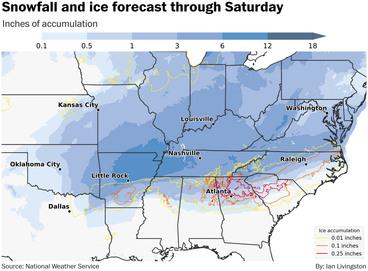
Major winter storm in the southern U.S. The same jet stream dip that helped whip up California’s firestorm is moving east through the south-central United States. Winter storm warnings stretch from Texas and Oklahoma to coastal Virginia as the storm system heads toward the East Coast Friday through Saturday. In addition to 4 to 8 inches near the Red River already fallen, the focus shifts to the Mississippi Valley region where half a foot or so will accumulate Friday. Significant ice accretion is possible on the southern end, especially in north Georgia near and north of Atlanta.
Historic Los Angeles wildfires. At least 10 have been killed and more than 9,000 structures impacted by ongoing fires in southern California. Both numbers are expected to rise. Despite occurring in locations that often witness wildfires, experts believe it could end up the costliest in American history. The current episode of high winds is easing, but a critical risk remains in place east of San Diego Friday and a new round of dangerous fire weather is possible early next week.
United Kingdom’s coldest night. A pattern with high pressure in the Arctic has allowed the nippiest weather of winter to shift southward across the United Kingdom. A low of 6 degrees (-14.5 Celsius) in Altnaharra, Scotland, on Friday was the coldest January temperature in the UK since 2010. Other than not-for-sale Greenland, the UK and U.S. are presently the coldest in the northern hemisphere relative to normal. The current spell is shifting to mainland Europe where it will dissipate.
Friday Focus
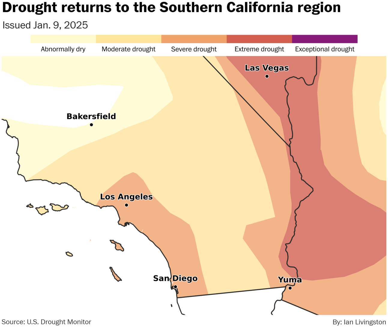
I shared a water-year-to-date map of the western U.S. on Thursday showing how California has been very dry south and quite wet north.
Since then, the U.S. Drought Monitor released its weekly update, indicating drought expansion in the Los Angeles region and elsewhere across the Southwest. Highlighting the rapid expansion, the city went from no drought to abnormally dry with the Dec. 10 update, reached moderate drought on Dec. 30 and ticked to severe drought Thursday.
Dry conditions are a primary driver of the ongoing fires. The region went drought free in 2023 into 2024 before a lengthy spell of little to no rain set in and persists today.
About
A weekday newsletter, The Weather Retort is part of a larger project I am spinning up that will offer focused, informed, and personalized weather and climate data for you and/or your business.
Reply