- The Weather Retort
- Posts
- Erin churns east of the Bahamas as U.S. heat shifts to new home
Erin churns east of the Bahamas as U.S. heat shifts to new home
Ian Livingston
August 18, 2025
Hurricane Erin reached Category 5 — the most powerful hurricane category on a 1 to 5 scale — over the weekend, the first storm of the Atlantic season to become so strong. It happened on the early side as a majority of Category 5s cluster in September during the peak of the season. While it has diminished in intensity since, Erin still dominates the headlines as it meanders the Atlantic.
Weather watch

Erin update. Hurricane Erin had a big weekend, reaching Category 5 on Saturday and then weakening a bit amid a size increase Sunday. The storm had 130 mph winds at 5 a.m. and was forecast to see intensity spike again Monday, heading toward a forecast secondary peak of 145 mph. It’s poised to miss landfall, and another system is expected to develop in its wake over coming days, while portions of the N.C. Outer Banks are under evacuation order for coastal flooding potential.

Shifting U.S. heat. The focus of intense heat today is on the Mississippi Valley region and surrounding spots, where extreme heat warnings are up for Little Rock and Memphis with advisories surrounding the warnings across a large area. Highs Monday are expected to rise near and above 100 in these cities, among other locations. Over time, the worst of the heat will shift to the Southwest while cooler air invades the Great Lakes and Northeast.
Lightning links
Flash floods devastate Buner, Pakistan after rare cloudburst kills hundreds. (Akhtar Soomro and Saeed Shah, Reuters)
Expect smaller broccoli in UK supermarkets if heatwave continues, farmers warn. (Malcolm Prior and Jenny Kumah, BBC)
Monday morning weather maps (Erin edition)

Ever since The Weather Retort came to be, it seems major weather events like happening on a Friday or during the weekend (in other words: after the workday newsletters are done for the week).
In that spirit, and with the potential suggested Friday, Erin ran past early forecasts bringing it to a low-end Category 4.

Reather, Erin rapidly exploded to a Category 5 hurricane with 160 mph sustained wind on Saturday morning, increasing to that speed from a mere 70 mph tropical storm the day prior. The explosive deepening of the central pressure to 915 millibars made it the most rapidly intensifying storm on record before September, according to meteorologist Sam Lillo.
Ahh, climate change.
Since then, the storm underwent an eye-wall replacement cycle, plus something I scientifically call an embiggening, and it is now back in position to strengthen again.

It will struggle to hit Category 5 a second time, but that can’t be ruled out.
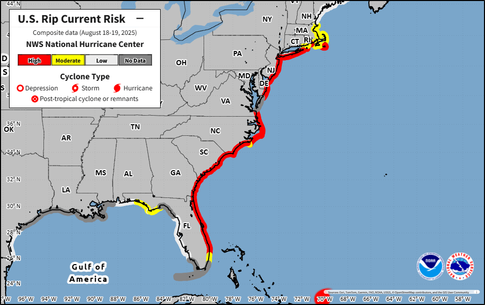
Erin will probably drive right through the middle of the uprights — if those uprights are Bermuda and the U.S. East Coast. Potentially life-threatening large waves and rip currents will be the main impacts on our shores.
About
Weekday morning newsletter by a journalist/forecaster. Connecting weather and climate change dots while occasionally stirring the pot.
Find this interesting? Forward it on and tell a friend!
Reply