- The Weather Retort
- Posts
- Powerful spring storm to exit East Coast with more on deck
Powerful spring storm to exit East Coast with more on deck
Australia is facing additional extreme weather with Alfred ahead.
Ian Livingston
March 05, 2025
The first of what should be several cross-country storms for the Lower 48 is exiting stage right today after packing a punch. Widespread high wind impacts are or will be common for much of the landmass east of the Rockies. As of Wednesday morning, there are 500,000 power outages and at least two confirmed deaths amid swaths of wind damage and isolated tornadoes in the South.
Weather Watch
Spring storm. The finale of a multi-day stretch of severe thunderstorms is here. A threat of severe weather runs from northern Florida up the East Coast to the shore of Lake Erie. A zone from the eastern Carolinas to southeast Virginia is at the highest risk for damaging wind and tornadoes.
Alfred visits Australia. Tropical Cyclone Alfred reached the equivalent of Category 2 status off the east coast of Australia on Tuesday. It’s slowing down for an eventual turn westward for a rare landfall in the region. It’s forecast to come ashore near Brisbane as a much weaker storm packing sustained winds around 60 mph. Even in a weakened state, it will bring flooding rain and damaging wind to the area.
Wet West Coast. Several storms are headed for California and the western U.S. Next week could feature a long-lived and powerful one for a portion of the region. Both the 6-10 day and 8-14 day outlooks from the Climate Prediction Center call for strong chances of above average precipitation in and around California. That’s good news, as central and southern parts of the state, as well as the Desert Southwest, are in deepening drought.
Lightning links
Dallas, Austin shrouded by dust storm sweeping across Texas.
Japan may declare ‘severe disaster’ as record wildfire burns for eighth day.
Yellowstone snow removal takes up to three months to prepare for spring.
Midwest mixed bag
On the cold side of the ongoing storm, blizzard warnings are up for portions of Iowa, through Wisconsin and to the Upper Peninsula of Michigan. The region has largely been missed by big snows this winter given a storm track favoring areas farther south.
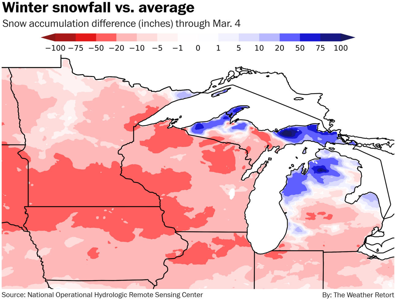
Minneapolis has seen less than half its normal snow through March 4 with 18.8 inches compared to an average of more than 40 inches. Chicago’s 14.8 inches is also less than half its normal to-date, while Des Moines’ 11.3 inches is about a third the typical.
However, locations downwind of the Great Lakes have generally seen a bountiful one. Gaylord in northern lower Michigan is nearing 200 inches, a record for there since the 1990s. I looked at why so much snow has fallen off the lakes last week.
About
Weekday morning newsletter by a journalist/forecaster that connects weather and climate change dots while occasionally stirring the pot.
Find this interesting? Forward it on and tell a friend!
Reply