- The Weather Retort
- Posts
- Plains to Midwest blizzard on tap with winds set to rage yet again
Plains to Midwest blizzard on tap with winds set to rage yet again
Extremely critical fire risk returns to the Southern Plains on Tuesday.
Ian Livingston
March 18, 2025
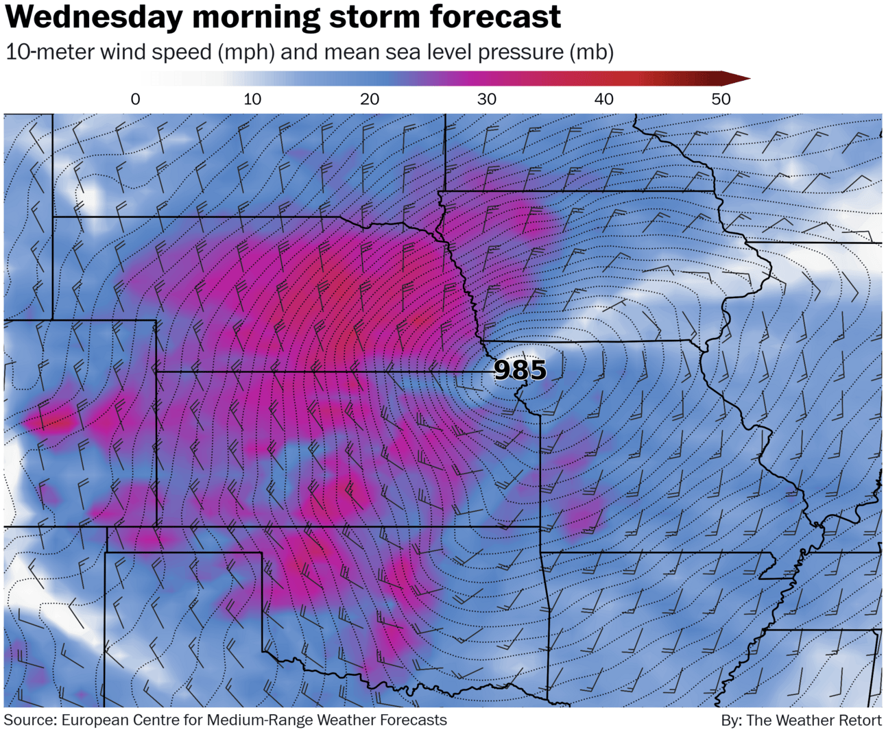
Glancing only at the surface low pressure forecast, it’s a case of déjà vu as yet another strong storm system traverses the midsection of the United States over coming days. Partly because the last storm pushed much of the available warmth and moisture back into the Gulf and beyond, this one will be wintrier.
Weather Watch
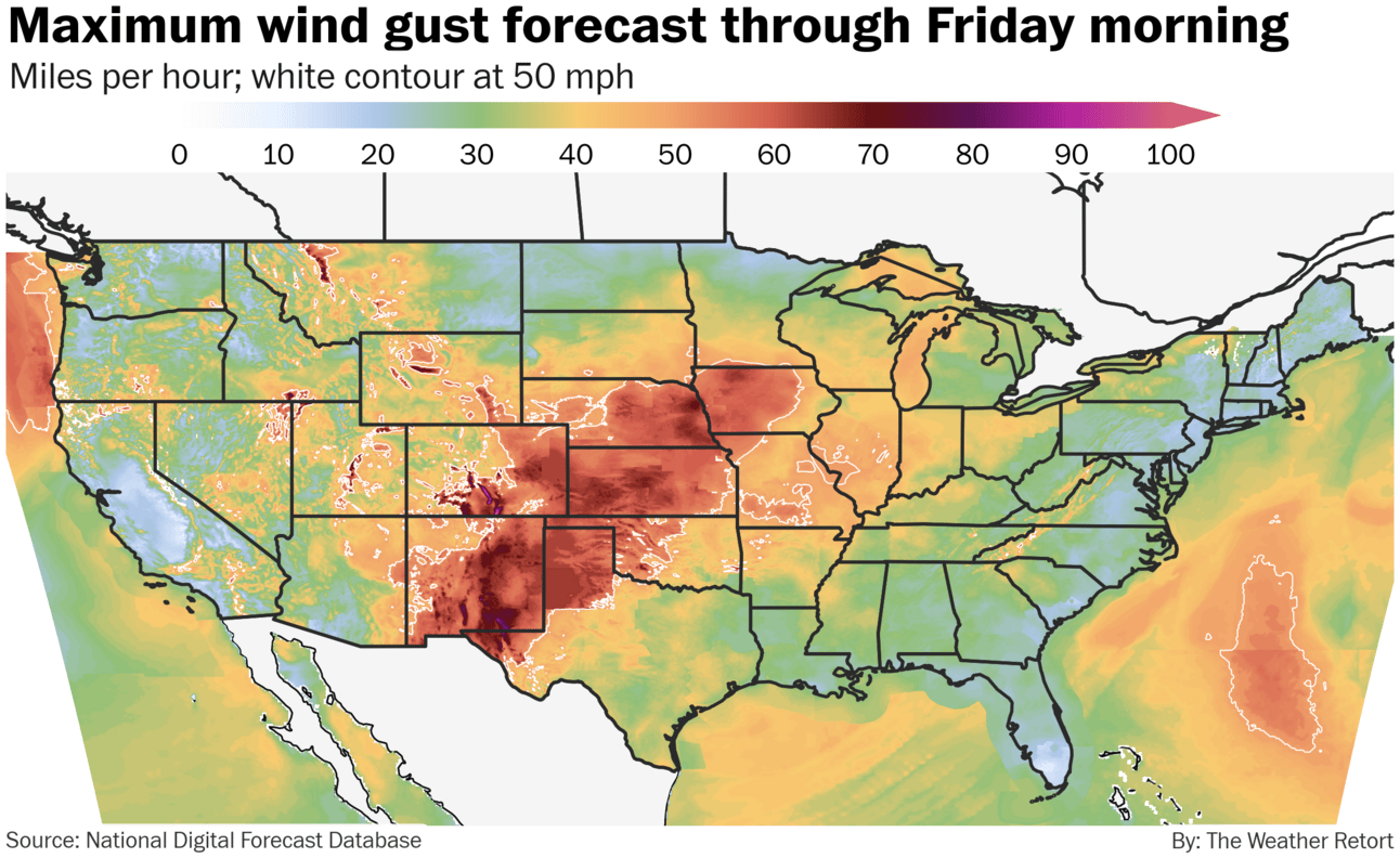
Fire weather flares. Another strong low-pressure area is moving across the Plains today into Wednesday. Wind gusts at or above 50 mph are forecast from the U.S./Mexico border near El Paso then northeastward through Iowa. Level 3 of 3 fire risk covers much of west Texas and the panhandle as well as parts of New Mexico and Oklahoma — red flag warnings are up for a larger region. I looked at the threat, and why it keeps happening, with Matthew Cappucci.
Springtime blizzard. The same storm system enhancing wildfire risks will deliver a blizzard from the central Plains to western Great Lakes region. Blizzard warnings stretch from the Kansas/Nebraska border through southern Minnesota, with winter storm watches surrounding. Whiteout conditions are likely amid widespread gusts to 50 mph that may peak around 65 mph. About 4-to-12 inches can be expected along much of the track, with the heaviest totals north.
Lightning links
Hurricane Center flags first disturbed area of weather in the Atlantic this year.
Paragould, Arkansas, had a second tornado strike in 10 months with the recent outbreak.
Tornado Tuesday
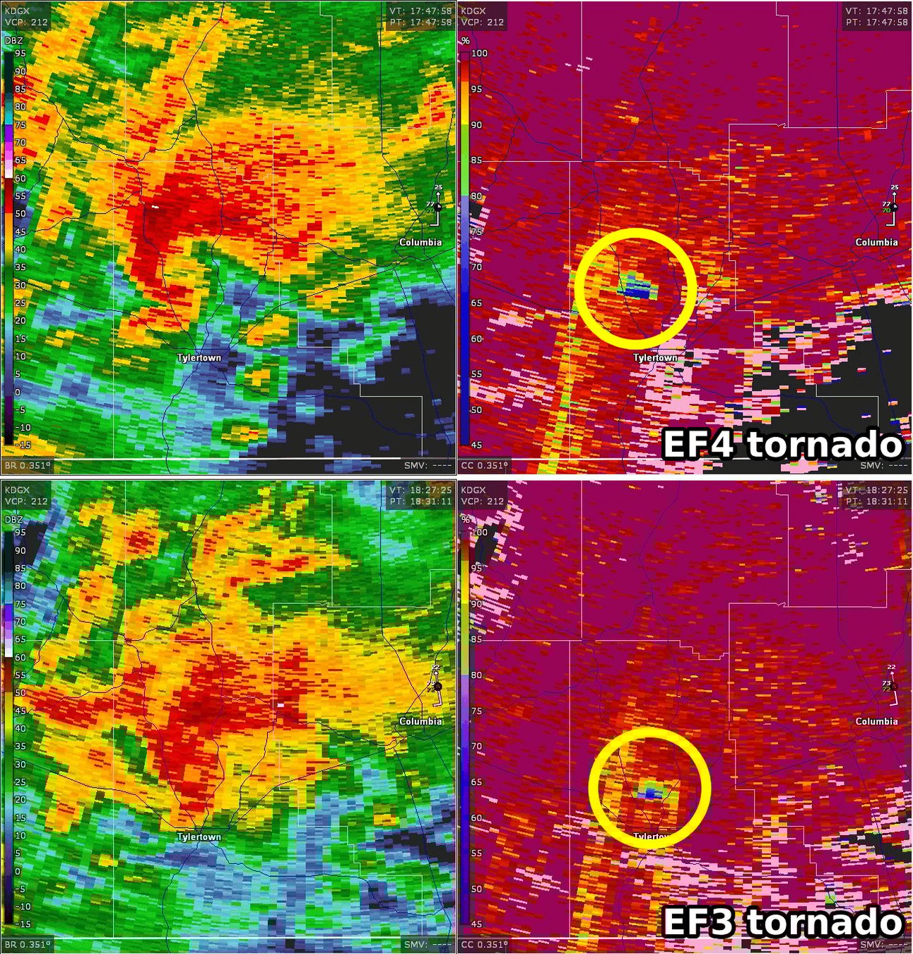
Radar grabs from Saturday. (Gibson Ridge)
Among the dozens of tornadoes that touched down last Friday and Saturday across the Midwest and South, at least three EF4s occurred. Two were in Arkansas on Friday night and one in Mississippi on Saturday.
Violent tornadoes are those rated either EF4 or EF5 on a 0 to 5 scale.
It’s the first outbreak with three violent tornadoes since April 2020, an event that struck a similar part of the South. It’s also the first outbreak since 1997 in Arkansas with more than one violent tornado in that state.
One of the three violent tornadoes was preliminarily rated to have maximum winds of 190 mph, which is on the cusp of an EF5. There have been no confirmed EF5s in the United States since Moore in 2013, although non meteorological factors may be the primary reason for that.
The EF4 in Mississippi was followed by an EF3 that tracked within miles of Tylertown, and the first tornado, about 45 minutes later.
About
Weekday morning newsletter by a journalist/forecaster that connects weather and climate change dots while occasionally stirring the pot.
Find this interesting? Forward it on and tell a friend!
Reply