- The Weather Retort
- Posts
- Northwest United States under the gun from sprawling storm
Northwest United States under the gun from sprawling storm
It's also been really cold or really warm in December.
Ian Livingston
December 17, 2025
A storm traversing the border region of the United States and Canada is the big weathermaker at present. It’ll eventually impact much of the country. For now, the focus is on the western half as it overtakes a big chunk of that region.
Weather Watch
Big border storm. Much of the northwest quadrant of the Lower 48 is under wind warning or other wind alert as a significant storm moves from the Pacific Northwest to the northern Plains over the next two days. There are also blizzard warnings for the Cascades, the Olympics and portions of northeast Montana. More flooding rain is expected in parts of Washington already reeling from such and a fire threat may materialize in and around Denver.

(National Weather Service)
Polarized December pattern. The first half of December has been about as cold as it gets these days in a big chunk of the eastern United States. On the other side of the country, the west has been toasty — except where fog has been super-persistent in California’s Central Valley. In D.C., it’s the coldest first 16 days of December since 2005, while it’s the coldest since 2010 in Chicago, and the coldest since 2013 in Minneapolis. Meanwhile, Portland, Ore., is seeing the warmest December on record to date.
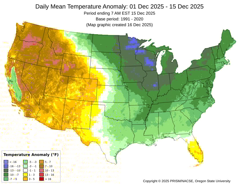
(PRISM Climate Group)
Lightning links
Trump moves to dismantle major US climate research center in Colorado. (Joey Garrison, USA Today)
2025 has been the UK's sunniest year on record. (Sarah Keith-Lucas, BBC)
Pancake ice creates rare spectacle on Lake Michigan amid frigid temperatures. (Olivia Stephens, FOX Weather)
About
Weekday MWF morning newsletter by a journalist/forecaster. Connecting weather and climate change dots while occasionally stirring the pot.
Find this interesting? Forward it on and tell a friend!
Reply