- The Weather Retort
- Posts
- It's like Tuesday all over again in the Mid-Atlantic
It's like Tuesday all over again in the Mid-Atlantic
Texas flash flood toll worst in decades.
Ian Livingston
July 09, 2025
If you remember yesterday and live in the Mid-Atlantic region, today is looking quite similar. If you’re dreaming of snow, scroll on down below.
Weather Watch
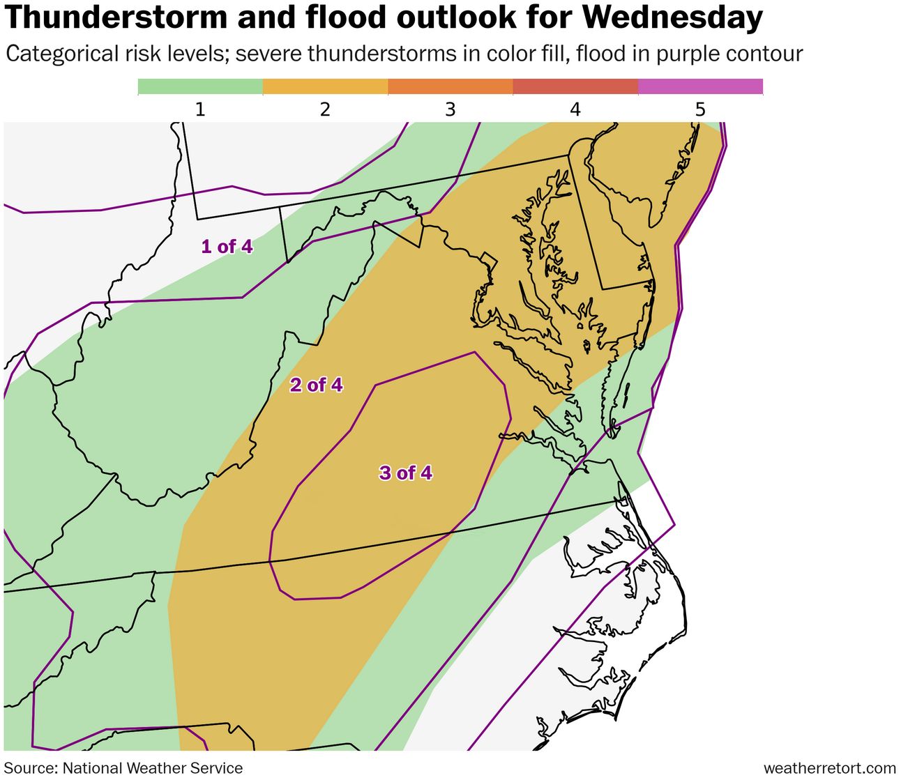
Stormy déjà vu. Flood watches are again in effect for a chunk of the Mid-Atlantic as another round of strong storms and heavy rain is anticipated Wednesday. Cities at risk for this activity include Philadelphia, Baltimore, D.C., Richmond and Raleigh. The NWS has a Level 3 out of 4 flood risk up for parts of Virginia and a Level 2 out of 4 severe storm risk for much of the broader region.
Summer snow. In between heat domes over western and eastern Europe, snow fell in the Alps as a dip in the jet stream brings unusually chilly weather to central portions of the continent. Up to several inches fell at relatively low elevations in the Alps on Tuesday.

Lightning links
'Swarm' of earthquakes at Mount Rainier not cause for concern, officials say. (Alex Didion, King 5 Seattle)
Hundreds of animals rescued after Texas storms. (The Weather Channel)
Texas flash floods worst since at least 1976
Other than extreme heat, flooding is the deadliest weather disaster annually in the United States, killing an average 113 per year over the past decade.
The death toll in Texas from the Independence Day flooding is now at least 110. On Tuesday it was announced more than 160 people were still missing in the hardest hit Kerr County.
During late 2025, the historic Hurricane Helene caused at least 95 flood-related deaths among the 250 killed overall. Hurricane Katrina in 2005 is the worst flood disaster in recent memory in the country, with about 1,800 fatalities mainly due to water inundation.
Katrina’s flood came after a levee failure, and it was a comparably slow rise.
The last flash flood — rapid and major water level increases — that was as bad or worse is the infamous Big Thompson River flood of 1976, when 144 were killed.
In that case, thunderstorms developed over high terrain of Colorado on the afternoon of July 31, with reports of 12-14 inches in several hours. As water funneled down mountains and into canyons, the Big Thompson River quickly crested at 30 feet and a flood wall raced down its length, catching many off guard.
The Texas event already ranks among the worst flash flood disasters in the U.S. and may climb higher on the list as the result becomes fully known.
About
Weekday morning newsletter by a journalist/forecaster. Connecting weather and climate change dots while occasionally stirring the pot.
Find this interesting? Forward it on and tell a friend!
Reply