- The Weather Retort
- Posts
- Europe heat still on blast and Flossie hits Category 3
Europe heat still on blast and Flossie hits Category 3
With a front clearing the East Coast, the U.S. is comparatively quieting.
Ian Livingston
July 02, 2025
With a cold front clearing the East Coast through Wednesday, a bit of a lull in active weather is hitting just in time for the Fourth of July holiday. As you might expect nearing the heart of summer, the main stories out there are heat and tropical related.
Weather Watch
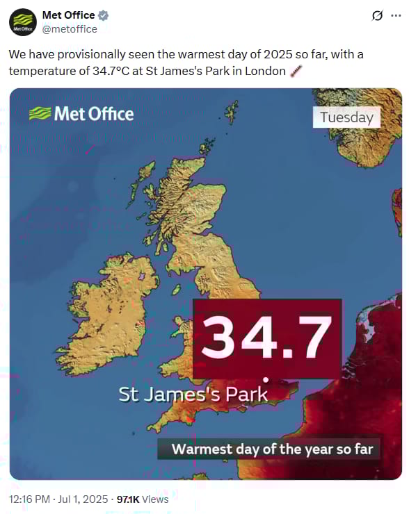
Europe heat. Hot temperatures continue their hold on much of Europe Wednesday. The focus has shifted to central and eastern Europe although the UK recorded its hottest day so far this year on Tuesday with a 95-degree (34.7 Celsius) reading in London. Records have been and will again be widespread in locations like Germany on Wednesday.
Fabulous Flossie. The sixth named storm of the active eastern Pacific hurricane season reached Category 3 major hurricane status overnight. It peaked at 115 mph sustained and is expected to rapidly weaken running into cooler water starting today.
Lightning links
Trump admin tries to kill the most indisputable evidence of human-caused climate change by shuttering observatory. (Andrew Freedman, CNN)
Storm chaser stages whirlwind proposal with real tornado. (Monica Danielle, AccuWeather)
Wither severe?
It’s looking the part of July on the Storm Prediction Center website this morning.
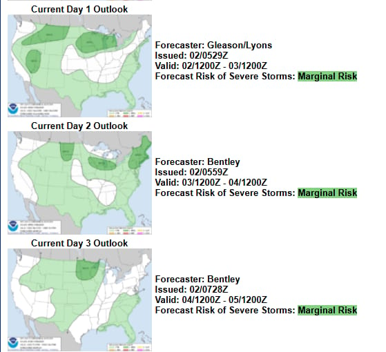
Now beyond peak season for tornadoes (April-June) and most other severe weather hazards, nothing more than a low-end severe weather threat is apparent in coming days.
The main cause is a typical one — jet stream winds are increasingly shunted into Canada. We can largely thank an expanding summertime subtropical high pressure over the southern U.S. and surrounding regions for that.
With the jet stream goes the wind shear — a change of wind and speed with height — needed for larger-scale severe weather episodes. When enough moisture makes it that far north, it is prime time in Canada for severe weather in the weeks to come.
Further south, impingement of jet stream activity can still threaten organizes severe storms at times if less frequently. With the whole country seeing toasty conditions of July, thunderstorms are often numerous if sub-severe, and they will often produce localized flooding rain given slow movement.
About
Weekday morning newsletter by a journalist/forecaster. Connecting weather and climate change dots while occasionally stirring the pot.
Find this interesting? Forward it on and tell a friend!
Reply