- The Weather Retort
- Posts
- Erick makes history as major hurricane in Mexico
Erick makes history as major hurricane in Mexico
Storms and heat dominate much of the continent north of the hurricane.
Ian Livingston
June 19, 2025
Erick made landfall early this morning as the earliest-on-record major hurricane in the region it struck. To the north, summer is taking hold. Unless you’re in Montana.
Weather Watch
Explosive Erick. Hurricane Erick did the thing. Rapid intensification since yesterday bumped it from a weak hurricane to a powerhouse Category 4 overnight. With sustained winds peaking at 145 mph. The storm came ashore during the pre-dawn with winds around 125 mph.
High heat. The first major heatwave of summer is revving up and will shift east through the weekend. It kicks off with highs near 100 in the Intermountain West on Thursday as extreme heat watches fly for the upper Midwest. By Monday and Tuesday, most spots in the Great Lakes to Mid-Atlantic and Northeast will threaten records.
Summertime snow. While summer will be official in all senses of the word, a heavy wet snowfall is on the way for high elevations of the northern Rockies in western Montana and adjacent southern Canada. There’s a winter storm watch up for elevations above 4,000 feet in Glacier National Park, where up to a foot or more could fall in the highest elevations.
Lightning links
Temperatures surpass 29C as UK heads for heatwave.
Cruise ship breaks loose in Alaska during storm.
Tornado strikes near Pikes Peak in Colorado.
Stormy week
It’s been an active week for severe weather across the country and today offers another round as a finale to this episode.
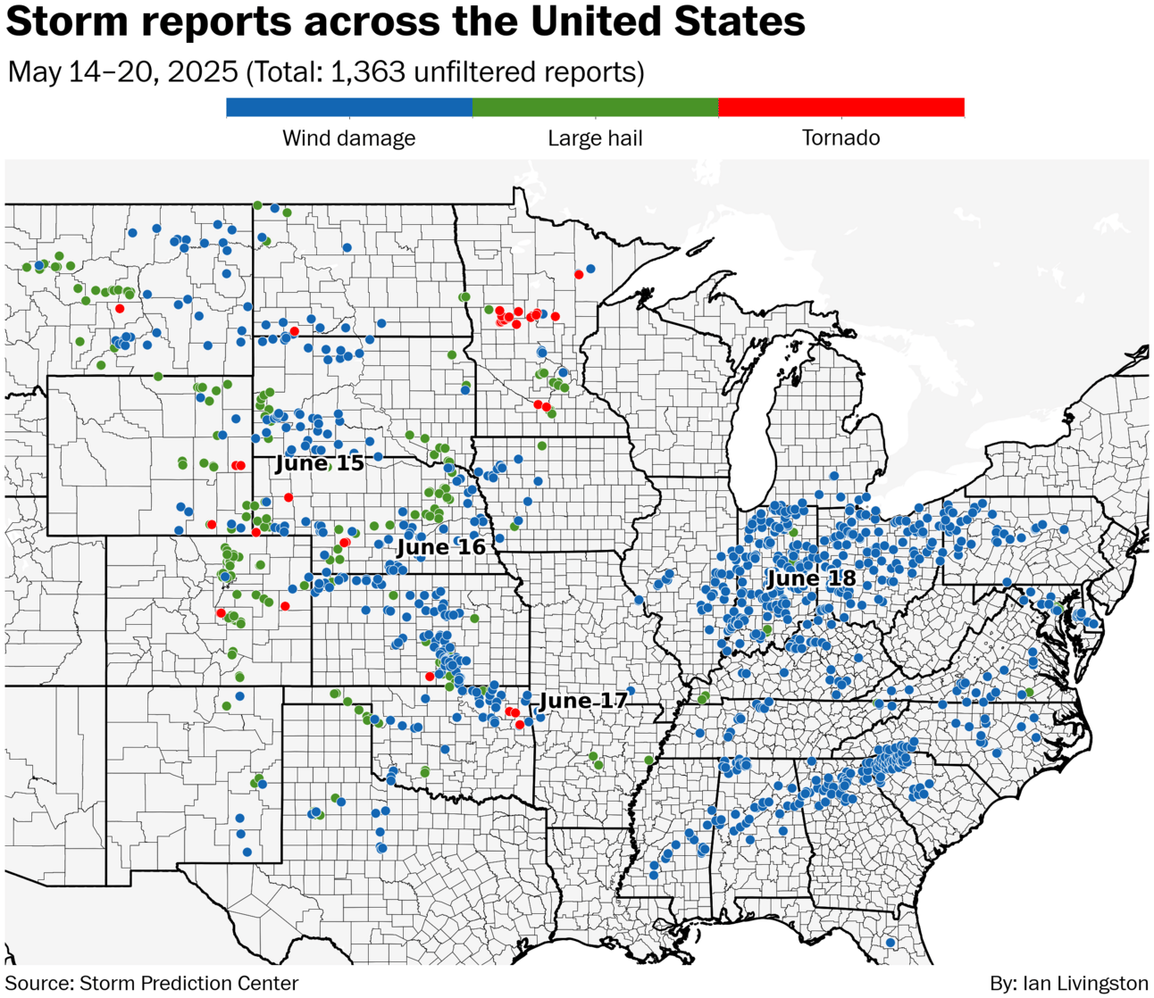
About 1,400 reports of high wind, tornadoes and hail have been logged thus far since Sunday. In addition to one of the more stunning tornadoes you’ll see, in Nebraska on Monday, more than a dozen twisters also touched down in Minnesota and widespread wind damage hit Indiana and Ohio yesterday.
Indeed, Wednesday alone delivered more than 500 reports and growing.
Today’s focus is on the Interstate 95 corridor, from around Richmond to New York City. The main threat will be wind damage, but a couple tornadoes and some large hail are also possible.
There’s a good chance next week will be as active, or perhaps more so. A dip in the jet stream is scheduled to take up shop in the northwest U.S. as high-pressure flexes in the east. This should mean rounds of severe storms in the north-central portion of the country and southern Canada.
About
Weekday morning newsletter by a journalist/forecaster. Connecting weather and climate change dots while occasionally stirring the pot.
Find this interesting? Forward it on and tell a friend!
Reply